

Post-Quantum Cryptography-Protecting Our Life From Quantum Computers with Modern Computers
Author(s)
Jen-Yu Han, Yan-Ting Lin, Jo-Yao HsuBiography
Dr. Jen-Yu Han holds a Ph.D. degree in Civil Engineering from Purdue University, USA. He is now a Professor at the Civil Engineering Department at National Taiwan University, Taipei, Taiwan. He also serves as the Duty Director at the NRCEE-NTUCE Joint AI Research Center. His research interests include geodetic reference frames, error theory, deformation analysis, lidar system, integration and intelligent applications of spatial information.
Academy/University/Organization
National Taiwan University-
TAGS
-
Share this article
You are free to share this article under the Attribution 4.0 International license
- ENGINEERING & TECHNOLOGIES
- Text & Image
- October 21,2020
The particle size of a riverbed determines the characteristics of water flow in a river channel. In turn, the flow characteristics affect the river’s velocity, riverbed erosion, and siltation phenomena. Particle size is a key index parameter in water management and planning simulation. In the past, riverbed particle size surveys could only be conducted by taking samples on site, and then manually identifying them. Additionally, labor resources and costs limited the effectiveness of the survey results. However, with the rapid development of remote sensing technology, such as light detection and ranging (LiDAR), a research project supported by the Ministry of Science and Technology in Taiwan aimed to develop a subfootprint LiDAR-based technique for riverbed particle size analysis. Using the LiDAR sensor’s altitude, attitude, and surface geometry, the subfootprint LiDAR-based technique was used to reconstruct the standard reference waveform template, and riverbed particle size was analyzed to detect subtle changes in the riverbed surface. The team’s research and development results demonstrated that this technique can approximate the standard reference waveform template with more than 85% accuracy, and detect particle sizes ranging from 10 cm to 100 cm. The results obtained during the survey using the subfootprint LiDAR technique revealed a unit particle size with a 3-cm difference from previous measurements conducted by an on-site river management unit. This trend confirms the reliability of full-wavelength optical subfootprint technology. In the research process, the LiDAR-based technique provided an efficient approach to analyzing the roughness, long-term changes, and alluvial characteristics of riverbeds. The adoption of this technique will facilitate land conservation efforts and help prevent and mitigate flood-related disasters.
Taiwan’s tall mountains, lush forests, and rugged terrain shelter winding streams that emerge from within forests and flow through urban towns to plain development areas. Over hundreds of kilometers, these streams travel through different riverbeds, such as huge rock masses, broken rock blocks, pebbles, coarse and fine sands, and mudflats, eventually entering the ocean. Geological conditions and significant differences in channel particle size also result in differences in flow conditions, such as flow velocity and water level, between river sections. River management units previously chose particular river sections to analyze, measured their elevations, took photographs, mapped their terrain elevation geometries, and recorded their riverbed particle sizes. However, river-by-channel section surveys require substantial human labor resources in the field, and manual identification is still required after the collection of terrain data and photographs. This can introduce uncertainties, such as human error, into the analysis of results. Therefore, effectively providing automatic detection of riverbed roughness for an entire river section is an important research topic related to water conservancy and spatial mapping.
In recent years, researchers have achieved technological advances in the area of remote sensing detection through developing new technologies and equipment. Researchers have applied these new technologies to monitoring surface changes through image shooting and signal transmission from altitudes of up to 100 km. One such technology, light detection and ranging (LiDAR), measures distance as a function of the time interval between transmitted and received signals sent from LiDAR to each point on the ground. In related research, this technology has mostly been applied to detect and use some features in a single waveform as surface characteristics. Researchers have rarely applied a complete mathematical model to simulate and interpret the physical characteristics of the waveform. Professor Han of the Department of Civil Engineering at National Taiwan University and his team used full-waveform LiDAR combined with echo waveform characteristics (e.g., amplitude, wave width, and backscatter), and proposed using subfootprint templates to determine surface roughness.
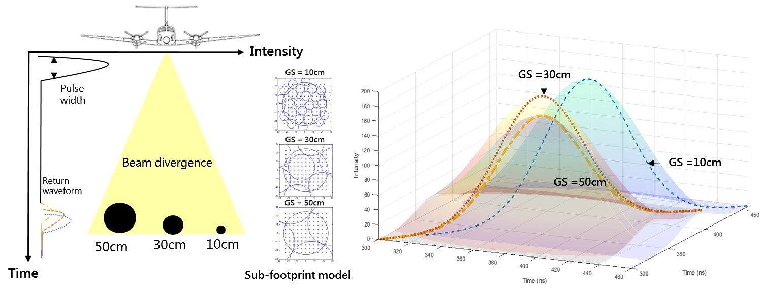
The subfootprint template is constructed in the ideal full-wave pulse signal transmission. The waveform signal is sent from the transmitter to the surface of the riverbed within the subfootprint. The process includes scattering, reflection, and reception. The waveform between transmissions is based on a Gaussian distribution. The emission energy follows a one-dimensional Gaussian distribution, and scattering follows a two-dimensional Gaussian distribution. The total instantaneous emission energy and footprint division correspond to the instantaneous emission energy and the split point. Information such as elevation can help researchers reconstruct the transmitted and received waveforms as a function of time. Various subfootprint templates can be simulated and constructed according to the emission’s height, energy, and scattering angle, as well as various riverbed particle sizes. These templates allow researchers to match actual light arrival waveforms to estimate the particle size roughness of the current river channel. The research results revealed that this method can be used to approximate the standard reference waveform template with more than 85% accuracy, and detect particle sizes from 10 cm to 100 cm, as shown in Figure 1. Compared with the river management unit’s previous results, the subfootprint LiDAR technique measured a 3cm difference in unit particle size, confirming the reliability of the full-wavelength optical subfootprint LiDAR technology.
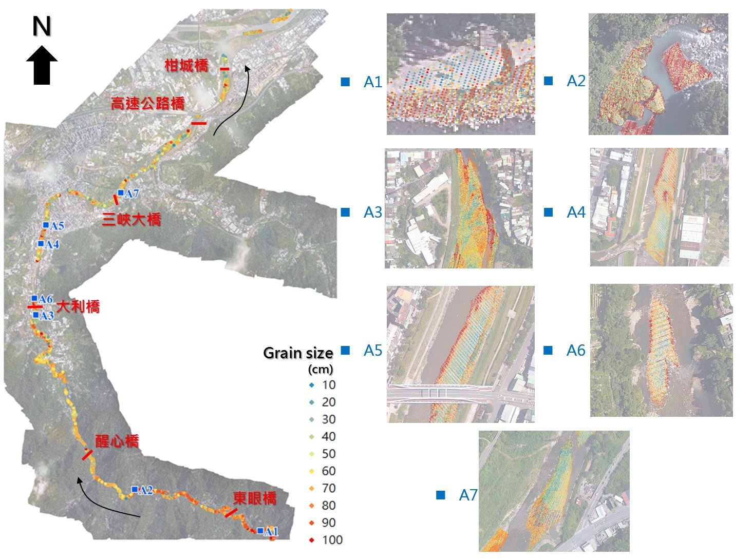
Figure 1. The standard Sub-footprint LiDAR templates detect river particle sizes from 10 cm to 100 cm.
The research team combines new spatial information technology and environmental analysis applications to solve the labor force and time cost issues related to on-site riverbed quality surveys. Subfootprint and reliable roughness results were obtained, facilitating the development of a highly efficient method of obtaining riverbed roughness values in the future to assist in the analysis of riverbed changes and alluvial characteristics. The team will continue to extend the application of remote sensing detection technology, especially by integrating detailed spatial information such as that from drone images, automatically assisting surface identification, and landform monitoring. The technique provides an efficient approach to obtaining riverbed roughness values, and assists in the analysis of long-term riverbed changes and alluvial characteristics, which will contribute to land conservation and the prevention and mitigation of flood-related disasters.
RELATED

STAY CONNECTED. SUBSCRIBE TO OUR NEWSLETTER.
Add your information below to receive daily updates.