

Post-Quantum Cryptography-Protecting Our Life From Quantum Computers with Modern Computers
Author(s)
Chein-Way HwangBiography
Chein-way Hwang is chair professor, Dept of Civil Engineering, National Yang Ming Chiao Tung University (NYCU). He has joint professorships in IES/AS and National Central University. His fields of research are satellite geodesy, satellite oceanography, and space and ground-based gravimetry. He teaches surveying, satellite geodesy, and the theory and methods of parameter estimation.
Academy/University/Organization
National Yang Ming Chiao Tung UniversitySource
Hsiao, Y.S., Hwang, C., Cheng, Y.S., Chen, L.C., Hsu, H.J., Tsai, J.H., Liu, C.L., Wang, C.C., Liu, Y.C., Kao, Y.C., 2016. High-resolution depth and coastline over major atolls of South China Sea from satellite altimetry and imagery. Remote Sensing of Environment, 176, 69–83.
Hwang, C., Chang, E.T.Y., 2014. Seafloor secrets revealed. science, 346(6205), 32-33.
Sandwell, D.T., Müller, R.D., Smith, W.H., Garcia, E., Francis, R., 2014. New global marine gravity model from CryoSat-2 and Jason-1 reveals buried tectonic structure. Science, 346(6205), 65-67.
Yu, D., Hwang, C., Andersen, O.B., Chang, E.T.Y., Gaultier, L., 2021. Gravity recovery from SWOT altimetry using geoid height and geoid gradient. Remote Sensing of Environment, 265, 112650.
-
TAGS
-
Share this article
You are free to share this article under the Attribution 4.0 International license
- ENGINEERING & TECHNOLOGIES
- Text & Image
- January 02,2022
Three-quarters of the earth’s surface is the sea. The seafloor topography influences ocean circulation, seabed resources, biodiversity, and interpretation of tectonic evolution. Satellite measurements are helpful for us to understand the global seafloor topography. An oceanic area with active satellite seafloor mapping is the South China Sea (SCS), which is a semi-closed sea with complex geological structures. Satellite altimeters measure the sea surface heights (SSHs) which can be used to compute marine gravity anomalies and oceanic depths. The vertical gravity gradient (VGG) is the vertical derivative of the gravity anomaly, which is more sensitive to short-wavelength seafloor features than the gravity anomaly. The present satellite altimeters can only observe nadir point SSHs along satellite ground tracks, and cannot provide a coherent, 2-dimensional seafloor topography. This data sampling problem will be resolved by the future SWOT mission, which uses a synthetic aperture radar altimeter to scan SSHs over a 120-km wide swath along its sub-satellite tracks. With the advanced SWOT altimeter mission, the research team may discover more tectonic features in the SCS from space.
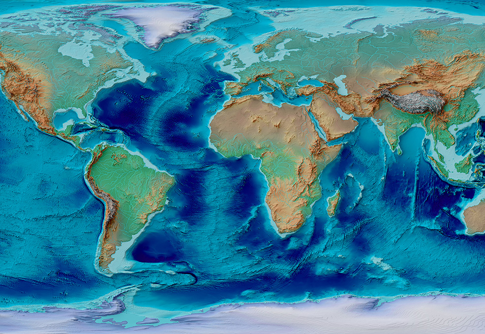
Three-quarters of the earth’s surface is the sea. What is the seafloor beneath the sea surface like? You may think that it is as sandy and flat as the beach, but the fact is that the seafloor topography is the same as the land surface, covered with mountains, plateaus, basins, valleys, among many other features. The seafloor topography influences ocean circulations, seabed resources, biodiversity, and interpretation of tectonic evolution, but it cannot be directly observed from space because the electromagnetic waves emitted from satellites cannot penetrate seawater. Usually, the depths to the seafloor are surveyed by ships equipped with echo sounders, but shipborne mapping is expensive and slow. In addition, more than 80% of the seafloor remains unexplored. The deficiency in seafloor mapping can be compensated by satellite measurements. An oceanic area with active satellite seafloor mapping is the South China Sea (SCS), which is a semi-closed sea with complex geological structures. This article will show the SCS seafloor features using satellite altimetry.
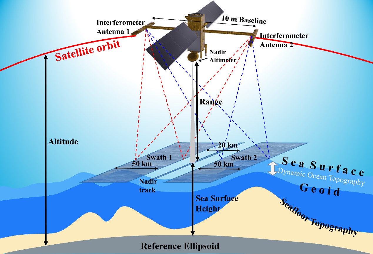
Figure 1. (a) Illustrations of the SWOT altimetry principle (Yu et al., 2021). The seamounts exert gravitational forces on the sea surface around them, causing the geoidal height to rise by a few cm. The present satellite altimeters can only observe nadir point SSHs along satellite ground tracks, but the future SWOT mission will scan SSHs over a 120-km wide swath along its sub-satellite tracks.
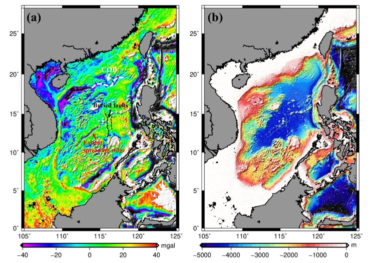
Figure 2. (a) The gravity anomaly, and (b) the bathymetry in the SCS (https://topex.ucsd.edu/index.html). Figure (a) reveals the COB, buried faults, and the extinct spreading ridges.
How altimeter observations on the sea surface are used to compute the seafloor topography in the SCS using the seafloor pattern is explained in Figure 1. The seamounts exert extra gravitational forces on the sea surface around them (compared to a flat seafloor), causing the sea’s equipotential surface to rise by a few cm. The rise creates larger geoidal heights, deflections of the equipotential surface, and eventually larger gravity anomalies. Using a mathematical relationship between gravity anomaly and oceanic depth, the latter can be computed from the former. Figure 2 (b) shows the bathymetry in the SCS determined in this way.
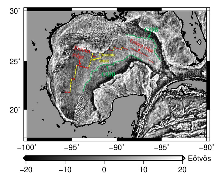
Figure 3. The VGG in the Gulf of Mexico (Sandwell et al., 2014). The VGG discovers extinct spreading ridges, fracture zones, and COB.
The accuracy and resolution of a satellite-based seafloor topography are critically dependent on the accuracy and resolution of the altimeter observations. The present satellite altimeters can only observe nadir point SSHs along satellite ground tracks, and cannot provide a coherent, 2-dimensional seafloor topography. This data sampling problem will be resolved by the future mission “Surface Water Ocean Topography” (SWOT; https://swot.jpl.nasa.gov/) to be launched in November 2022. SWOT’s altimeter is different from the present nadir-looking altimeters, in that it uses a synthetic aperture radar (SAR) altimeter to scan SSHs over a 120-km wide swath along its sub-satellite tracks, as shown in Figure 1. A team in Taiwan, formed by faculty members and students from National Yang Ming Chiao Tung University and National Taiwan University will work with NASA/JPL and France/CNES to calibrate the SWOT-observed SSHs in the mission’s validation phase (about 3-6 months into the launch).
With the advanced SWOT altimeter mission, the research team may discover more tectonic features in the SCS from space. But there are many technical challenges in using such data for discovery, including methods for removing systematic and random errors in the data and a fast and precise method for converting the raw observations from SWOT to oceanic depths. The international team members of SWOT are working on all these technical challenges to get a better view of the global seafloor.
RELATED


STAY CONNECTED. SUBSCRIBE TO OUR NEWSLETTER.
Add your information below to receive daily updates.