

Ultralow-threshold Plasmonic Nanolaser by Using a Single Quantum Dot

Author(s)
Yih-Min WuBiography
Prof. Wu is a Professor / Chair of Dept. Geosciences, National Taiwan University. He works in the fields of real-time seismology and seismotectonics. In the past few decades, he has become one of the leading figures in earthquake early warning.
Academy/University/Organization
National Taiwan UniversitySource
- Wu, Y. M., D. Y. Chen, T. L. Lin, C. Y. Hsieh, T. L. Chin, W. Y. Chang, W. S. Li, and S. H. Ker (2013). A high density seismic network for earthquake early warning in Taiwan based on low cost sensors, Seismo. Res. Let. 84, 1048-1054, doi: 10.1785/0220130085.
- Wu, Y. M., W. T. Liang, H. Mittal, W. A. Chao, C. H. Lin, B. S. Huang, and C. M. Lin (2016). Performance of a low-cost earthquake early warning system (P-alert) during the 2016 ML 6.4 Meinong (Taiwan) earthquake, Seismo. Res. Let., 87, 1050-1059, doi: 10.1785/0220160058.
- Wu, Y. M., H. Mittal, T. C. Huang, B. M. Yang, J. C. Jan, and S. K. Chen (2019), Performance of a Low-Cost Earthquake Early Warning System (P-Alert) and shake map production during the 2018 Mw 6.4 Hualien (Taiwan) Earthquake, Seismo. Res. Let., 90, 19-29, doi: 10.1785/0220180170.
-
TAGS
-
Share this article
You are free to share this article under the Attribution 4.0 International license
- NATURAL SCIENCES
- Text & Image
- July 19,2019
A research team from National Taiwan University (NTU) developed an earthquake early warning (EEW) device using a low-cost microelectromechanical system (MEMS) accelerometer named “P-Alert.” It can provide an onsite alert after initial shaking is detected. Owing to the low cost of P-Alert accelerometers, the research team was able to develop a high density real-time strong motion network in Taiwan. Now, about 700 P-Alert stations are installed in Taiwan. Most are located in elementary schools to provide onsite early warning. The P-Alert network also produces detailed shake maps within two minutes after the occurrence of a large earthquake. Now the real-time shake map from the P-Alert network is transferred back to the National science and technology Center for Disaster Reduction (NCDR) for emergency response. The high shaking regions of the P-Alert shake map strongly correlated with the locations where damage and casualties were reported. The individual P-Alert provided a 4 to 8 s lead time before the arrival of violent shaking in the earthquake source region during the 2016 Meinong and 2018 Hualien earthquakes. The P-Alert system is promoted to India, China, Korea, Indonesia, Vietnam, the Philippines, Greece, New Zealand, Mexico and the Solomon Islands. It is also very important to society for seismic hazard mitigation, especially in developing countries which are located on plate boundaries.
The MEMS accelerometers were introduced in seismic applications in the early 1990s. These small low-cost sensors have proven to be efficient for recording strong ground motion shaking. Taking the advantage of MEMS technology, a research group at NTU along with a private organization developed a MEMS accelerometer P-Alert system, which is specially designed for EEW. With the support of the Ministry of Science and Technology (MOST) of Taiwan, NTU initiated a pilot experiment in 2010 by installing a seismic network with 15 MEMS P-Alert accelerometers in eastern Taiwan. Encouraged by the functionality and ability of these small MEMS devices to record earthquakes in Taiwan, this network was extended to other areas of Taiwan (Wu et al., 2013, 2016, 2019). Currently, 700 P-Alert stations have been installed all over the country. Most of these stations are located in elementary schools where adequate power and Internet connections are provided. Data from these P-alert systems are transferred continuously to a central processing station.
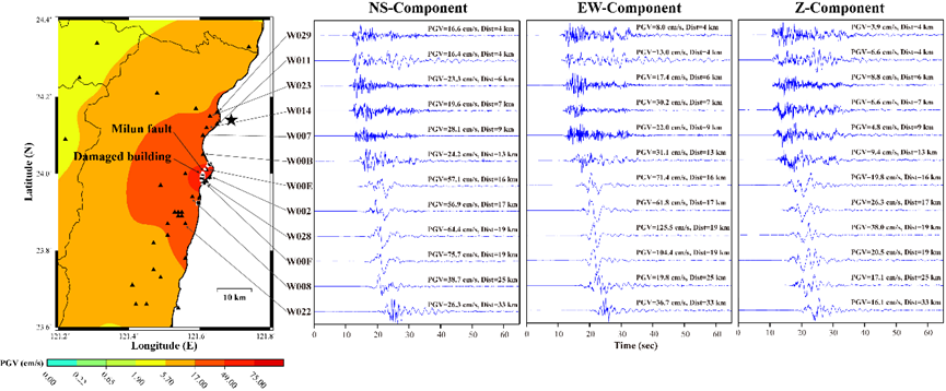
During the 2016 M6.4 Meinong and 2018 Hualien M6.3 damage events, the P-Alert network recorded high quality strong motion signals and produced detailed shaking maps within two minutes after the earthquake occurrence. The high shaking regions of the P-Alert intensity map strongly correlated with the damage and casualty locations. In addition, this system also shows the potential to identify the rupture direction, which is one of the key indices used to estimate possible damage. Figure 1 shows the near real-time peak ground acceleration (PGA) shake map produced by the P-Alert system during the 2018 Hualien earthquake posted on social media and delivered to NCDR. Figure 2 shows the PGA and peak ground velocity (PGV) maps during the 2016 Meinong earthquake produced by the P-Alert system. The solid squares in Figure 2 show the location of 11 buildings which suffered structural damage. The geographical distribution of the damaged buildings is in agreement with the PGV shake map, as most of them are located in regions where the PGV is larger than 17 cm/s. It is worth noting that the distribution of the aftershock sequence is much more coherent with the high PGA pattern. However, the distribution of the structurally damaged buildings is much closer to the high PGV pattern (Wu et al., 2016).
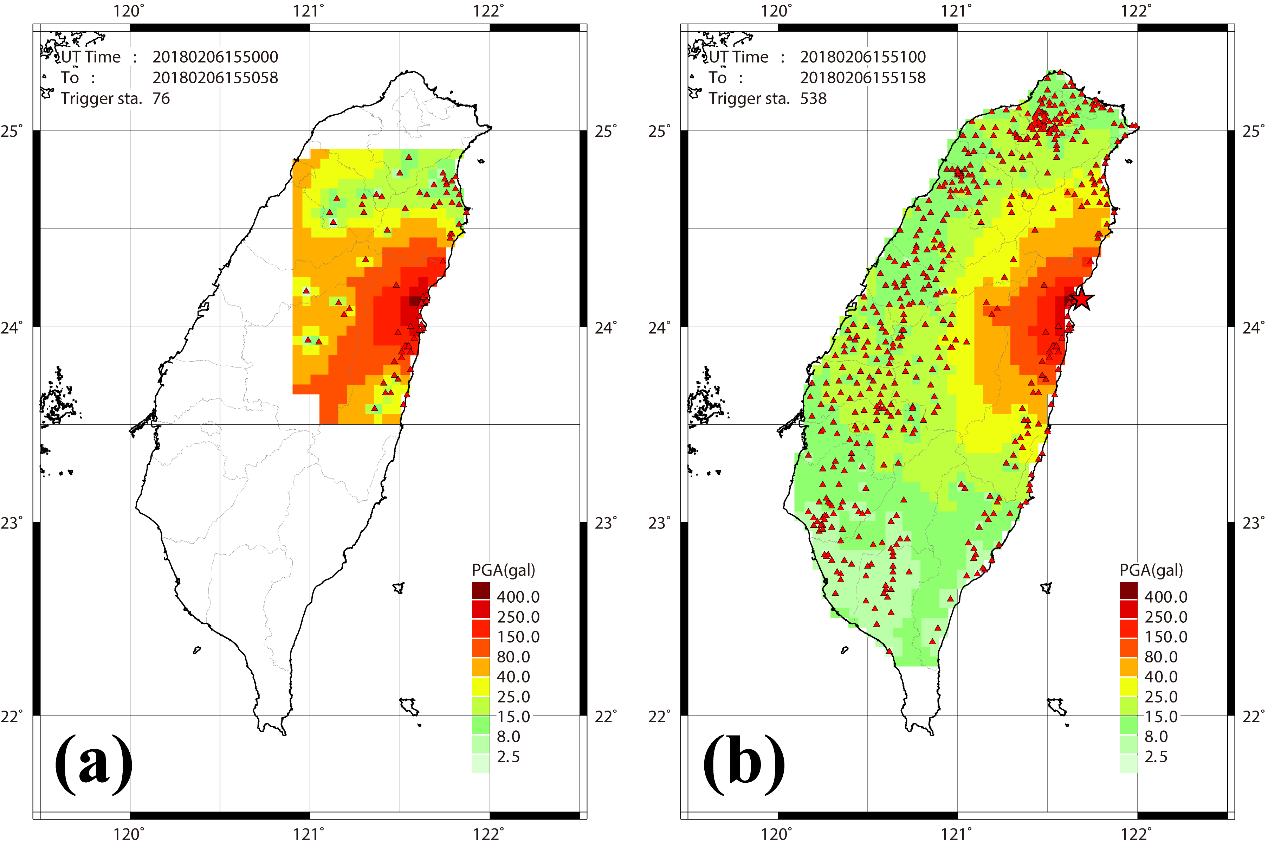
Figure 1. PGA shake map of the 6 February 2018 M_w 6.4 Hualien earthquake produced by the P-Alert network. (a) The first shake map from about a few seconds after the earthquake occurrence with the triggering of 76 instruments. (b) The shake map after all available P-Alert instruments were triggered (Wu et al., 2019).
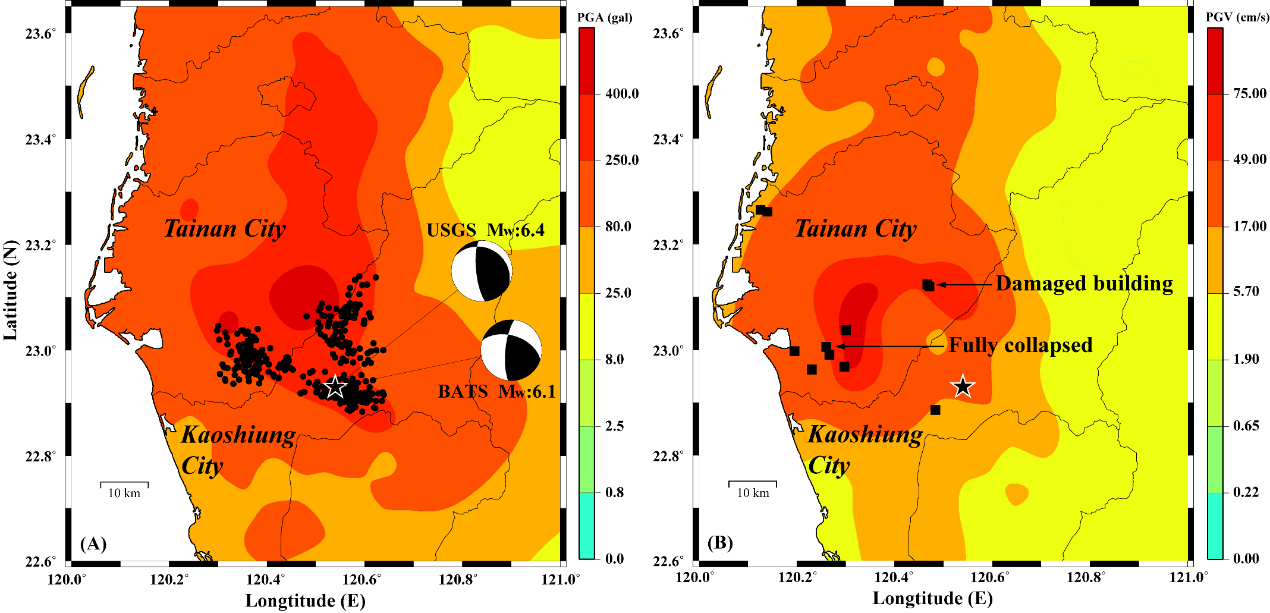
Figure 2. (A) PGA shake map of the earthquake source regions and focal mechanisms as well as aftershock distribution of the 2016 Meinong earthquake reported by the Central Weather Bureau (CWB). (B) PGV shake map of earthquake source regions. Solid squares show the sites of the structurally damaged buildings. Most of them are located in the areas where PGV> 17 cm/s (Wu et al., 2016).
Individual P-Alert devices also serve as an onsite earthquake early warning system. They provide an alert when the P wave vertical displacement amplitude exceeds 0.35 cm or PGA > 80 gal (Wu et al., 2013).
The P-Alert network worked very well for on-site warning during the 2016 Meinong and 2018 Hualien earthquakes. Figure 3 shows the lead-time for PGA and PGV around the epicenter of the 2018 Hualien earthquake. The warning time for PGA or PGV ranges from 2 to 8 seconds. The average PGA lead-time is 4.5 seconds while for PGV it is 4.2 seconds. The instruments placed closest to the damaged building that caused 17 fatalities reported relatively high lead-times (6-8 seconds; Wu et al., 2019). For the most damaged regions in Tainan City during 2016 Meinong earthquake, the P-Alert onsite method can provide about 5 to 8 seconds lead time before PGA or PGV arrival (Wu et al., 2016).
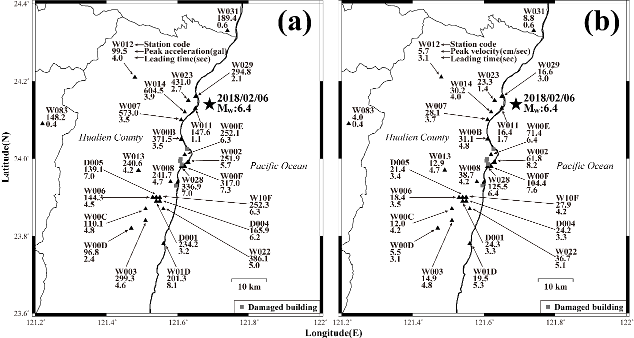
Figure 3. Early warning lead time distribution for the P-Alert network during the 2018 Hualien earthquake. (a) Lead time based on PGA. (b) Lead time based on PGV. Solid squares show the location of the damaged buildings (Wu et al., 2019).
As a result of its low cost, the P-Alert device may have commercial potential. The EEW system can be established for relatively little expense. Results from the P-Alert network in Taiwan are encouraging for the further utilization of the EEW system in other countries. Thus far, P-Alert devices have been installed in India, China, Korea, Indonesia, Vietnam, the Philippines, Greece, New Zealand, Mexico and the Solomon Islands. It is also very important to society for seismic hazard mitigation.
RELATED


STAY CONNECTED. SUBSCRIBE TO OUR NEWSLETTER.
Add your information below to receive daily updates.