

Taiwan AI Labs Founder Ethan Tu: With PTT Netizens’ Mobilized Spirit, Taiwan Has Become a Role Model in the Application of Sm...
Author(s)
Chih-Chung KaoBiography
General Manager of GEO informatics Co., Ltd.
Founder and Chairman of Crossover Strategy Co., Ltd.
Vice President of Project Management Institute Taiwan Chapter
Associate Professor, Department of Counseling Psychology and Human Resource Development, National Chi Nan University
Adjunct Assistant Professor, Department of Urban Planning and Spatial Information, Feng Chia University
Vice Chairman of China Agriculture, Tourism, Culture and Creative Development Association
Executive Director of Taichung Advertising Creative Society
Academy/University/Organization
informatics Co., Ltd.-
TAGS
-
Share this article
You are free to share this article under the Attribution 4.0 International license
- HUMANITIES & SOCIAL SCIENCES
- Text & Image
- June 01,2021
In recent years, Taiwan has been committed to the development of rural tourism. In order to improve the quality of rural experiences and to market industries in rural areas, the government has invited domestic and foreign tourists to visit rural areas through diversified marketing strategies. In the policy-making process of promoting and optimizing rural tourism, objective quantitative data are often the key, but are difficult to obtain for decision-making. In order to assist the effectiveness of the policy, the GEO informatics company assisted the Council of Agriculture (COA) in developing a set of data science-assisted rural tourism promotion strategies. A three-stage method, including "data integration and diversification," "analysis and verification specialization," and "forward-looking strategy formulation" involves the introduction of big data analysis and artificial intelligence technology in the technical aspect. It helps to achieve the ultimate goal of scientific rural tourism strategy policy making.
With its economic and social development, Taiwan is gradually facing similar phenomena to Japan, such as a decline in the total population, aging of the population, concentration of the population in cities, etc. Problems such as an imbalance between urban and rural areas, hollowing out of industries, and talent loss have emerged. To cope with this issue, industry, government, and academic organizations have been working on “Placemaking” for a decade. To put it simply, the term "Placemaking" means creating unique "experiences" through local characteristics, such as art, characteristic culture, creative industries, local products, site planning and design, etc., to deepen the connection between "people" and "land" and to drive the positive economic cycle in the local area. Among them, the promotion of rural tourism has gradually become an important tool for promoting the creation of rural areas.
In recent years, Taiwan has also begun to devote itself to the development of rural tourism. Various county and city governments and related units have successively launched different rural thematic trips. In 2016, the Council of Agriculture (COA) planned to conduct in-depth tourism by diversified marketing and cross-industry alliances. The COA planned to build 52 golden chain tours, connect 146 communities, and create a total of 416 rural attractions to encourage tourists to visit these areas.
Through diversified marketing and cross-industry alliances, domestic and foreign tourists are invited to visit the countryside together. At the same time, in order to improve the quality of their rural experience, we plan to improve the evaluation standards and methods of rural experience quality, to evaluate rural tours, and to award the "Quality Rural Experience Certificate" to improve the quality of rural experience services. In the policy process of promoting the optimization of rural tourism, objective quantitative data are often the key, but they are difficult to obtain for the decision-making and benefits of funding. In order to assist in the effective promotion of policies, the GEO informatics company has developed a set of methods to assist rural tourism promotion strategies with scientific data, through the three methods of "diversified data collection," "analysis and verification specialization," and "forward-looking strategy formulation." The stage is carried out by introducing big data analysis and artificial intelligence in technology, in order to achieve the ultimate goal of scientifically formulating rural tourism strategies.
Data collection and analysis
In terms of data collection, basic data collection and integration were carried out in the rural demonstration communities. Data sources include mobile communication big data, community data, government open data, community video records, etc. Through spatial visualization technology, we can understand the relevance and abundance of resources. Through cooperation with telecommunications companies, we can collect mobile signaling data after exclusion of personal information. Mobile signaling data is a data communication record (Data Communications Detail Records, DCDR) generated when a mobile communication device interacts with a base station used to generate a person’s Digital Footprint. We can use the following three steps to analyze user movement, and then produce travel-related information.
1. Distribution of visitor hot spots
The distribution of visitor hot spots per unit time can be obtained from the DCDR signaling data (Figure 1).
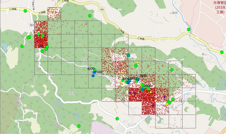
Figure 1. Distribution of hotspots of visitor flow
2. Exclude non-tourists (local residents)
After selecting the rural area, the local residents may cause the number of estimated tourists to be too high, so the non-tourist population needs to be excluded first. The team used the spatial grid as the basis to demarcate the rural area (Figure 2).
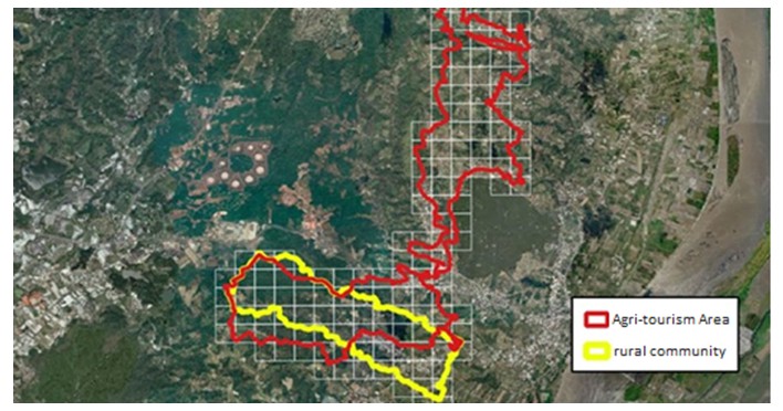
Figure 2. Definition of rural areas
3. Visitor movement analysis
After adding time variables to the DCDR signaling data, we can know the movement paths, stay time, path tracking, and movement rate of the flow of people. Through the flow analysis strategy formulated by the team, useful travel-related information can be produced (Figure 3).
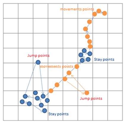
Figure 3: Crowd movement analysis strategy
In order to produce an accurate estimate of the number of passengers, we understand the gap between the DCDR signaling data and the actual situation. When the team selects a rural tourism activity, it uses aerial cameras to shoot videos of people flow, and then calculates the people flow using AI visual recognition technology to verify the correctness of the telecommunications data.
 Figure 4. AI crowd recognition
In addition, we also analyze whether there is a significant difference in the number of passengers with and without activities in rural areas, and continue to explore the factors that may affect the number of visitors (Figure 5).
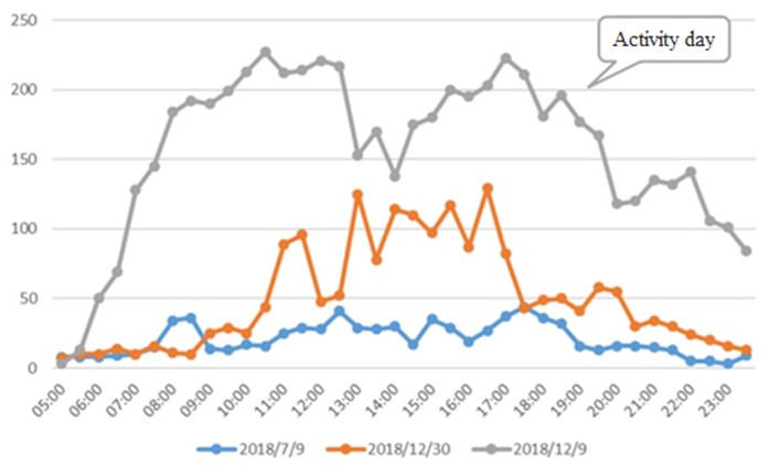
Figure 5. Statistics of the number of people on rural activity days
Scientifically formulate agricultural tourism promotion strategies
In order to establish the tourist arrival prediction model, we first collect the recreational attraction factor and the tourist arrival factor, convert the categorical variables into continuous variables through normalized operational definitions, and derive it through statistical methods such as t tests, PLS-SEM, and multiple linear regression analysis in order to formulate and build a forecasting model for each variable and the number of tourists. We applied big data and artificial intelligence technology to process and analyze the data, and tried to address a decision-making and performance tracking issue promoted by Placemaking from a scientific perspective. In addition to the use of intelligent tools, we also encompass opinions of local experts. In expert meetings we discussed and revised the key influencing factors of agricultural tourism. Finally, we combined with the high-quality rural experience evaluation consultant group to jointly formulate strategies, and developed a diversified and practical rural tourism development strategy.
RELATED

STAY CONNECTED. SUBSCRIBE TO OUR NEWSLETTER.
Add your information below to receive daily updates.